


Expert travel storyteller Jordan Adkins, founder of InspiredByMaps.com, brings a decade of adventures across 101 countries and 450+ UNESCO sites into rich, off-the-beaten-path narratives, melding ecological expertise with genuine, seasoned travel insights. His full bio can be found here.
Iceland is one of the world’s most magical travel destinations, a place of abundant and infinitely breath-taking must-visit locations including volcanoes, geysers, waterfalls, and hot springs. Not to mention the tiny elf houses (‘álfhól’ in Icelandic).
Here, there’s so much to see. It may seem a little daunting to first-timers, but becoming familiar with Iceland’s most famous landmarks is an excellent place to start …
In Iceland, there’s so much to visit; you might spend a lifetime enjoying its abundance and only just scratch the surface of what this enchanting island has to offer. Which why we have created this cheat sheet of the most famous landmarks of Iceland to assist you with your journeys.


But first of all — what even is a landmark?
A landmark is a recognizable natural or artificial characteristic that has become a local or national emblem, usually standing out from its surroundings. A landmark is valuable for navigation by modern visitors-both in terms of being a physical waypoint and in trying to assist you in coordinating your schedule.
It’s all well and good to get off-the-beaten-track, but at the end of the day, there are some places you really have to see when you travel to a country. Think of Gardens by the Bay in Singapore or the Las Vegas Strip. Immediately familiar locations that, if you tried, you could not miss. And there are plenty such famous landmarks in Iceland.


You’ll want to tick off as many popular Icelandic sights as you can as you undertake a trip to this mythical realm-and the best way to do that is always to take a tour or hire a car to get around. Public transport can be used a little, but personally, I’d recommend splurging on car hire and saving by attempting wild camping in Iceland.
In Iceland, there is a lot to discover, and no list of iconic Icelandic landmarks will ever be complete. But, we have tried to get the top highlights by putting a call out to our favorite travel bloggers and asking them to regale us with stories and helpful tips about their best-loved spots in Iceland.
This way, you have a reasonable frame of reference to inspire your Iceland travels from which you could choose a few landmarks that you absolutely cannot miss… or cram as many as possible into one trip.
If you plan it correctly and have ample time, you could just reach them all. And find plenty more of Iceland’s own highlights while you’re at it!


21 Famous Icelandic Landmarks To Plan Your Road Trip Around! 🇮🇸
Page Contents
- 21 Famous Icelandic Landmarks To Plan Your Road Trip Around! 🇮🇸
- Blue Lagoon Geothermal Spa
- Dettifoss
- Diamond Beach / Jökulsárlón Beach
- Fjaðrárgljúfur Canyon
- Gerðuberg Cliffs
- Grjotagja
- Gullfoss
- Hallgrimskirkja
- Harpa
- Kerið Crater
- Kirkjufell
- Mývatn Nature Baths
- Perlan
- Raufarhólshellir
- Seyðisfjörður
- Skogafoss
- Snæfellsjökull Glacier
- Sun Voyager
- The Arctic Henge
- The US Navy C-117D Sólheimasandur Crash
- Vik I Myrdal Church
Blue Lagoon Geothermal Spa
The Blue Lagoon is one of Iceland’s geothermal spas and is the most popular tourist attraction due to the remarkable blue mineral water. The Blue Lagoon is easily accessible when visiting Iceland for a few days or a long airport layover due to how close it is to the airport; it is located only 20 minutes from Keflavik Airport in Grindavik.
Unlike other hot springs in Iceland, the Blue Lagoon is not a natural spring. It is manmade from the runoff of the geothermal power plant that is nearby. The water is a mix of fresh and ocean water that comes from the volcanic aquifers 2000 meters within the earth. This mix of waters is known as geothermal seawater and is extremely high in minerals, making it safe for everyone to visit.
The Blue Lagoon facilities are nice and clean. The water area has been well planned out. The bottom of the spring is like a pool and made of white concrete. Due to the mix of waters, the water itself is bright blue and looks like magic with the steam rising from it. At the Blue Lagoon facilities, you will have access to a face mask, hair conditioner, a robe, flip-flops, showering locations, and drying stations.
When visiting the Blue Lagoon, the #1 thing to remember is that reservations are required. As part of your reservations, you have access to the mineral benefits of the water (with two face-masks), you can make reservations to visit the spa, and then catch a bite to eat at the Lava restaurant. If you are traveling with kids 13 and younger, then you will not need to pay extra for their entrance as kids are welcome free of charge. The Blue Lagoon is a must-visit tourist location for everyone during their trip to Iceland.
Explored by Tiffany from Mommy And Me Travels


Dettifoss
Dettifoss is located in the north of Vatnajokull National Park, which forms part of the Diamond circle in the north of Iceland. The nearest city to the waterfalls is Akureyri, which is 2 hours away. The waterfalls are 100 meters wide, and drop 44 meters with a rumble of loud thunder, making it the second most powerful waterfall in Europe, next to Rhine Falls.
The sight of the thundering waterfalls gushing into canyons is certainly an experience not to forget. The waterfalls can be reached from the east banks and west banks, both of which require extra caution.
The east bank can be reached by 864, an uneven gravel road, followed by a hike down the rough path along with the signpost. The west bank can be reached by driving in 862, which leads to the Dettifoss car park. From here, follow the walking trail for 1 km until you see the roaring waterfalls. The west bank is grassy, and most of the mist from waterfalls spray on this side, making the path very slippery. Follow the grassy path to reach the observation deck where you face the magnanimous waterfalls. There are some rope rails along the west bank, but none on the east side. So, do not attempt to get too close to the ridge.
There are many hiking trails that begin from both the banks, the most popular one being a short hike to Selfoss Waterfalls from the parking area. Fact for movie aficionados, this stunning waterfall appears in the opening scene of the blockbuster science fiction movie Prometheus.
The parking lot on the west side is free of charge. Do wear appropriate clothing and sturdy shoes while hiking in the Dettifoss. Wear a rain jacket; otherwise, you are likely to get soaked in the waterfall spray. Take extra caution when walking in either of the banks. Last, but not the least, don’t forget to capture the rainbow arch that frequently appears over the waterfall!
Explored by Anuradha from Country Hopping Couple


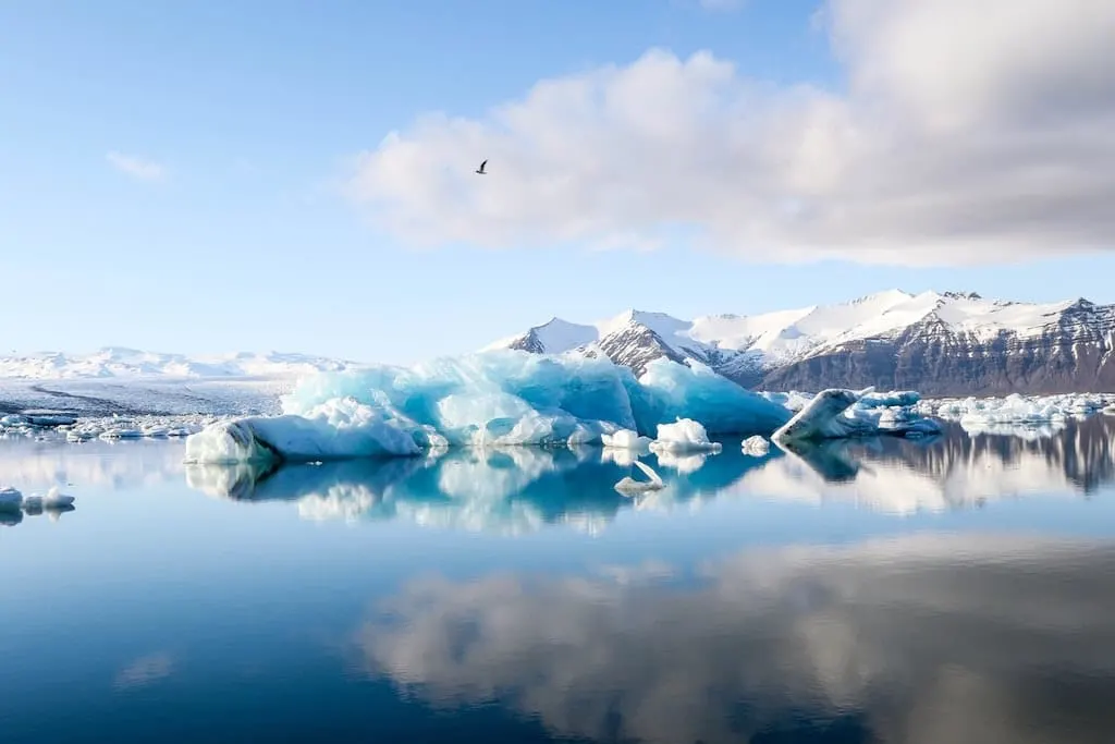
Diamond Beach / Jökulsárlón Beach
When I was planning our holiday in Iceland in Winter, the main thing on my list was to see the Diamond Beach. This name and images of big iceblocks stuck in my head, and I just had to see this place.
We packed the car and left Reykjavik early morning to see the Diamond beach, which is located approx 370 km from Reykjavík; and if you drive from Reykjavík, it will take you about 5 hours.
So what is Diamond Beach – its a black stone beach covered with big chunks of the iceberg being brought and taken away by the sea. Despite the cold weather, we spent there a long time seeing how the beach is changing. A piece of great advice for all you crazy Instagrammers out there is don’t try to take a photo of yourself standing on one of the “ice cubes” because as fast they appear on the beach; they are taken away even faster by the strong current. I have seen a few people being soaked while posing for the photo.
The best time for photos in here, especially in the wintertime, is at sunrise, and it’s easy as the morning light in December is after 11 am and sunset at 4 pm. So you have only a few hours, but on the other hand, if you arrive in summer, you can spend here the whole day, observing how every tide in and out, the scenery on the Jökulsárlón beach renews itself.
Explored by Ania James from The Travelling Twins


Fjaðrárgljúfur Canyon
Fjaðrárgljúfur is not just a mouthful to say; it is an ice age canyon you do not want to miss when visiting South Iceland. Fjaðrárgljúfur (pronounced as Fiath – raor – gliu – vur…try it, it’s fun) is different from how you would picture a typical rocky canyon. It is coated in a layer of mossy Iceland green, making it seem straight out of a fairy tale.
The palagonite bedrock is thought to be over two million years old. The canyon is located about 6 km west of the town of Kirkjubæjarklaustur, which boasts several waterfalls, including Systrafoss, Stjornarfoss, and also the Kirkjugolf church floor. From Ring Road, turn north on 206, which is a gravel road said to be accessible by 4×4 only, but several cars made their way through. After 2.3 kilometers, a small designated parking area is visible on the right before the bridge, but additional parking is available on the sides of the road leading to the trail.
There is no entrance fee, and a WC is available near the parking. The snake-like Fjaðrá river winds through the canyon. After a Justin Bieber video in 2015 that was partially filmed at the location, the traffic to Fjaðrárgljúfur increased dramatically, causing wear to this natural wonder. In order to prevent further damage, the canyon is now only open several months out of the year in the summer. It is advised to check online before going. The narrow serpentine canyon spans 1.24 miles in length and is over 320 feet deep.
There is an easy upper trail hike that takes less than an hour, leading to an observation deck over a stunning blue waterfall. The lower canyon is also accessible, but hikers need to wade through the cold river. This lower hike can take 4-5 hours, and most hikers opt for the upper viewpoints. For an off the beaten path adventure and views like no other, a hike up the winding Fjaðrárgljúfur canyon trail to the waterfall cannot be beaten.
Explored by Carol Vasel from isthisevenaroad.com

Gerðuberg Cliffs
The Gerðuberg Cliffs are one of the most striking sights in Iceland. The cliffs are around 500m in length and made up of hexagonal basalt columns, which were formed thousands of years ago after a volcanic eruption. Some of the columns are up to 14 m tall and 1.5m wide. Although they were formed naturally, they are so perfectly formed that they almost look manmade, and it is this feature that makes them such an iconic sight in Iceland.
They are located close to Borganes in the Snaefellsnes Peninsula in the northwest of Iceland, which is where you’ll find some of the most beautiful scenery in Iceland. You can easily make a loop of the Snaefellsnes Peninsula on a day trip from Reykjavik, but there are so many iconic sights to see that it’s worth spending a couple of days exploring.
The drive from Reykjavik to the cliffs will take about 90 minutes along Route 1 up to Borganes and then onto the I54. If you’re coming from Reykjavik, keep an eye out on the right-hand side for the cliffs and a small track. It’s about 5km after the turnoff for the I55. Despite their size, the cliffs are not that easy to see from the road if you’re not sure what you’re looking for.
When visiting, you can park at the bottom of the cliffs in a very small car park and climb up and over the cliffs (which is a bit of a scramble), or you can take a track up to the left of the cliffs (as you are facing them). The views from the top of the cliffs of the surrounding countryside, which has a slightly lunar-like appearance, especially in winter, are immense.
Explored by Jacquie Hale from Flashpacking Family


Grjotagja
Grjótagjá is a lava cave in Iceland, located near Lake Mývatn in the north of the country. The cave is a quick detour off the Ring Road and an easy stop on any Iceland itinerary.
Getting to the Cave: If driving clockwise on the Ring Road, Grjótagjá will be your second right after the town of Reykjahlíð (just go south on highway 860). The directions given by Google Maps are accurate, so you can follow those.
About the Cave: The cave’s beginning goes back to the 18th century, when an outlaw named Jón Markússon lived inside, making use of the thermal waters for bathing. The cave was later used by locals for swimming until, in the 1970s, Krafla volcanic eruptions caused the water in the cave to heat beyond 50 C – far too hot to swim in. Grjótagjá received new-found fame when it was featured in the Game of Thrones episode “Kissed by Fire” (the episode where Jon Snow and Ygritte got a little frisky).
Currently, the cave is a bit of a tourist attraction. Relatively unvisited (by Iceland standards), visitors can climb inside and photograph the cave. However, you’re not allowed to swim in it.
Insider Tip: Here is what to do if you want a photo of the inside of the cave – because it’s such a small space, you don’t have a lot of time to get the shot before you have to leave and let others in. What you’ll need: a DSLR (or similar) camera that lets you adjust the shutter speed and aperture; a small tripod (I like the Joby GorillaPod). Set your camera to TV (shutter speed priority) and set the shutter speed between 0.5 and 1 sec.
Explored by Mikaela of Voyageur Tripper


Gullfoss
Gullfoss is one of the most notable landmarks in all of Iceland as well as the most visited natural attraction in the country. This powerful waterfall is known for its tiered cascades, which gently stair-step down before abruptly plunging into the Hvítá river canyon. The waterfall makes a sharp 90-degree turn before dropping approximately 69 feet into the picturesque canyon.
In the early 1900s, there were discussions about damming up the Hvítá River and using Gullfoss to generate electricity for the island nation. Fortunately for the millions of people who visit Iceland each year to gaze at the waterfall’s power and beauty, the plan failed. Gullfoss is now a protected landmark.
Translated in English as “Golden Falls,” Gullfoss is one of the most breathtaking waterfalls in Iceland. As a popular stop along Iceland’s Golden Circle in the southern portion of Iceland, the attraction is easy to get to and free to visit. If you rent a car and do a self-drive, you can see Gullfoss and many of the other surrounding attractions in just 3 or 4 days in Iceland.
From the parking area for Gullfoss, you walk a short way down a narrow wooden boardwalk, and the waterfall will quickly come into view. The closer you get, the more mighty and majestic the waterfall appears. You can walk right up to its impressive cascades and even feel the mist as it comes off this stunning natural wonder in Iceland.
Explore by Melissa from Parenthood and Passports


Hallgrimskirkja
The church is iconic for Reykjavik, and a must-visit when you have two days in Iceland. With its 74,5 meters and standing on a hill, it’s visible from afar. It’s close to the old town of Reykjavik and directly recognizable as the church of Reykjavik when seen in pictures.
Hallgrímskirkja literally means the church from Hallgrímur. Hallgrímur Pétursson is the most famous poet and cleric of Iceland. He wrote anthems, and the church is named after him. The architect of the Hallgrímskirkja is Guðjón Samúelsson. His inspiration for the outside of the church comes from the basalt rock that you can find all over Iceland.
The outside of the church is made of white concrete and resembles the trap-rocks, mountains, and glaciers in the Icelandic landscape. This makes the building fit perfectly in its surroundings. The modernistic and icy outer appearance is perfect in combination with the ever-changing clouds in Iceland.
They started building the church in 1945, and it was finished in 1986. The inside of the church is sober, but beautiful. The highlight inside is the organ. The organ was made and added in 1992 by the German organ builder Johannes Klain. It’s 15 meters high and weighs almost 25 tons. The church can house 1200 people during service. Another special thing about the inside of the church is that at any given moment during the day, sunlight can shine inside.
The most special about the Lutheran church is that you can go up in the tower with an elevator and have a beautiful view over Reykjavik. With clear weather, you can see the whole city, harbor, and the coast in all directions. The ever-changing weather in Iceland makes for new views every time you go up.
In front of the Hallgrímskirkja stands a statue of Leifur Eiríksson, an explorer and presumably the first European colonist in Northern America. The USA gifted this statue in 1930 to remember 1000 years of the Alþingi (the Icelandic parliament). The statue is just as iconic as the church itself.
Explored by Cosette from KarsTravels


Harpa
Harpa is one of the best and most famous landmarks of Iceland, located in the heart of Reykjavik. It is a cultural and social hub and has spectacular views of the surrounding mountains and the North Atlantic Ocean. Harpa is a captivating destination for interested travelers, and since its completion on May 4, 2011, its majestic-scale award-winning design has attracted 10 million visitors.
One of the finest concert and conference facilities in Northern Europe, Harpa has won a myriad of awards and competitions – having even been called one of the best concert halls of the new millennium. It was designed by Henning Larsen Architects, who also are responsible for the Copenhagen Opera House.
Since the opening of the building, several concerts have taken place in Harpa, with a strong emphasis on musical diversity. The complex frequently hosts numerous music festivals, including Iceland Airwaves, Reykjavik Midsummer Music, Dark Music Days, Reykjavik Arts Festival, Reykjavik Jazz Festival, Sónar Reykjavík, Tectonics, and the Harpa International Music Academy. Harpa is also home to the Iceland Symphony Orchestra, the Icelandic Opera, and the Reykjavik Big Band, which are very widely attended and perform several concerts annually.
If you have the opportunity, attending a performance here is something you will never forget, like attending the Vienna Opera or a performance in the Teatro Colón of Buenos Aires. But, if you do not have time, just wander around inside and explore during the day to get an idea of the scale of the structure.


Kerið Crater
Kerið (sometimes Anglicized as Kerith or Kerid) is a volcanic crater lake situated along the famous Golden Circle route in the Grímsnes region of southern Iceland.
It is one of many crater lakes in the area, known as the Western Volcanic Zone of Iceland, which comprises the peninsula of Reykjanes and the glacier of Langjökull, generated as the ground moved over a localized volcanic hotspot. However, Kerið is the only one that is easily visually identifiable as a caldera. Like the other volcanic rocks in the region, the caldera is made up of red (instead of black) volcanic rock, and it is about 3,000 years of age.
The caldera is only about 55 m (180 ft ) deep, 170 m (560 ft ) long, and 270 m (890 ft ) wide – but is still stunningly beautiful, and worth visiting. The water is a distinctive and beautifully vibrant aquamarine shade of blue. The best way to enjoy the stunning view of this famous landmark of Iceland is to take an easy hike around Kerid crater.
While the majority of the crater is steep-walled with very little vegetation, one wall is more gradually sloped and engulfed with thick moss, and it can be descended reasonably easily. Kerið lake itself is pretty superficial (7-14 meters, depending on precipitation and other variables), but it is transparent and aquamarine because of minerals in the surrounding soil.
In order to see Kerið crater, you will need to pay an entrance fee of around 400 ISK (as of July 2020) to the local landowners.


Kirkjufell
Kirkjufell has been made famous by numerous photographs, including shots with the northern lights in the sky and a small waterfall in front of it. In fact, it is one of the most photographed mountains in Iceland. Kirkjufell has even been shown as a backdrop in season 7 of Game of Thrones as the mountain shaped like an arrowhead. However, Icelanders know the mountain as “church mountain.”
The mountain is 463 meters (1,540 feet) high; as one of the highest points in west Iceland, it is readily recognized from the road and can be seen from a variety of vantage points from either side of the road. The view from Kirkjufellfoss, one of Iceland’s many famous waterfalls, is a particularly great one as you can see the distinct shape of Kirkjufell.
Adventure seekers will delight in the intense hike up the summit of Kirkjufell. Though the hike is relatively short at approximately 1.9km (1.2 miles) round trip, you will need to scramble and use ropes to reach the summit. The hike can also be dangerous and slippery in wet weather. Sometimes it is also difficult to find the trail; however, if you make it up to the top, you’ll be treated to 360-degree views of the Snaefellsnes Peninsula.
Located on the Snaefellsnes Peninsula in the western part of Iceland, Kirkjufell and its waterfall can easily be found off of Road 54 just west of the town of Grundarfjordur. There are a few parking lots for Kirkjufell, and they are perfect for car camping if you want a chance at capturing the peak alongside Kirkjufellfoss and the northern lights. For those who prefer a cozier stay, there is also a cabin located at the base of Kirkjufell.
Explored by Constance from The Adventures of Panda Bear


Mývatn Nature Baths
A perfect road-trip in Iceland has to include a visit to one of the many natural thermal pools. One of the most iconic landmarks in Iceland is the Myvatn Nature Baths, located at the Myvatn Geothermal area and volcanic hills. It opened in 2004, and it is equivalent to the famous Blue Lagoon near Reykjavik.
If you are in northern Iceland, the Myvatn Nature Baths is an incredible experience. The warm water with temperatures around 36 to 40 degrees Celsius (97 to 104 Fahrenheit), surrounded by stunning scenery and away from the big crowds, makes it a great place to visit.
At the Myvatn Nature Baths, you can find a relaxing spa with hot tubs, steam baths, and a unique view over Myvatn Lake. You can also buy a “drink bracelet” when you arrive and order your favorite drinks – beer or wine, from the pool. The facility also offers showers, lockers, restaurants, and shops. The water is packed with minerals, particularly sulfur, which is good for respiratory and skin problems. Just remember that this is a geothermal area, so there is a sulphury smell, which you get used to.
You can rent a car in Reykjavik and drive to northern Iceland to visit the baths and the Myvatn region. It is one of the most diverse areas in Iceland with a lot of geothermal phenomena such as bubbling mud, dozens of seething fumaroles, and the iconic Myvatn Lake. The drive is around 6 hours (466 km), and the roads are easy to drive and, of course, very scenic.
Explored by Paula from Paula Pins The Planet

Perlan
Perlan Museum, aka Wonders of Iceland, is one of the most famous landmarks of Iceland. The round building sitting on top of Öskjuhlíð Hill overlooking the city has a long history.
The water tanks were originally built in the late 1930s-1940s, and it’s only in 1991 that the site was turned into a museum. Even today, several tanks are filled with geothermal water that serves as a giant radiator to heat the building in winter.
There are many reasons to visit Perlan. It’s one of the best places to get acquainted with all the natural wonders of Iceland in one place! In just a few hours, you can learn about geysers and volcanos, walk inside a real ice tunnel (it’s -15°C (5F), so dress warm!), and see the most incredible Northern Lights display. Yes, you read it correctly.
They have a wonderful show called Arora that allows you to experience auroras and stunning Icelandic winter landscapes in the planetarium. If you are visiting Iceland in summer or if bad weather prevents you from seeing the Northern Lights in Iceland in winter, the Perlan Arora show is a great alternative.
In addition, Perlan boasts some of the best 360° views of Reykjavik and the surroundings. So make sure not to miss the Observation Deck on the 4th floor of the museum. End your visit with a drink or a nice meal at the Perlan panoramic restaurant. The views from the glass dome at the restaurant are simply stunning!
Perlan is located just a bit outside of Reykjavik city center, about 20-30 minutes’ walk from Hallgrimskirkja. They also have a shuttle bus that’s included in your ticket and frequently runs between the museum and the city center. Here you can find more information about your visit to the Perlan Museum in Reykjavik.
Explored by Jurga from Full Suitcase


Raufarhólshellir
Iceland is a country that really captured our hearts. It’s stunningly beautiful in so many different ways. One place that really made an impact on us was the Lava Tunnel at Raufarhólshellir. It is the fourth largest lava tunnel in Iceland, and you can go on three different guided tours. One is a more family-friendly standard tour, another is an adventure tour only for the fit and healthy, and the third is an evening lava tunnel tour.
The Lava tunnel at Raufarhólshellir is billed as a ‘Must see in Iceland.’ It was formed by a volcanic eruption 5200 years ago. To walk in a lava tunnel is a really unique experience. It is one of the largest lava tunnels in Iceland.
When we visited, we had a little person with us, so we went on the one-hour standard tour. Over the winter, a lot of snow and ice forms in the tunnel. The sights created by this are stunning. The ice formations were staggering and like nothing we’d seen before. You walk in the path of where lava once flowed, and you can see the patterns from the flow on the walls of the tunnel. Where the tunnel has collapsed in three places, there were big mounds of snow that were out of this world. It was such a privilege to see.
Raufarhólshellir Lava tunnel is located just 30 minutes from Reykjavík and is easily accessed all year round. It is quite high up, so if it has been snowing, you may want to only visit with a 4×4. They even offer a tour that includes a bus trip from Reykjavik.
Explored by Suzy McCullough from Our Bucket List Lives

Seyðisfjörður
If you’re looking for the cutest towns in Iceland, Seyðisfjörður must be on your Iceland bucket list. Located between Mount Bjólfur and Strandartindur, this tranquil little town is a must-visit on the eastern part of the island.
Since it’s located on the East Fjords (660 km from Reykjavík), it’s best to include it in your Ring Road itinerary. You need to make a little detour from Egilsstaðir by leaving Route 1 and taking Route 93, which leads you right up to Seyðisfjörður. Although you can only find around 300 houses in the town, it’s possible to find accommodation if you want to stay in Seyðisfjörður, or you can just stay in the nearby Egilsstaðir instead.
Seyðisfjörður is mostly famous for its rainbow-colored path leading to the church, but you can also find a vibrant cultural scene in the town as well. You can visit an art studio, a telecommunication museum, or an arts center, and if you happen to be around in mid-July, you can also attend the LungA arts festival, which is a celebration for youth arts. In the summer season, you can go for a short hike or sail on the sea, while in winter, you can opt for one of the many ski slopes around the town.
The town is surrounded by snow-capped mountains and a beautiful view of the sea, and if it wouldn’t be enough, the multicolored wooden houses will surely leave you speechless. While tourism clearly has an important role, most of the local economy is still based on fisheries.
Explored by Krisztina Harsanyi from She Wanders Abroad

Skogafoss
Along the Southern Ring Road lies one of Iceland’s biggest attractions, the stunning 60-meter-high Skogáfoss waterfall on the Skógá River. Like many of Iceland’s famous landmarks, there is a related legend about a settler here who is believed to have hidden his gold chest under the waterfall of Skogáfoss a long time ago — kind of like leprechauns leaving pots of gold at the end of all the rainbows in Ireland.
If the conditions of the sun are favorable, a bright rainbow can be seen in front of the Skogáfoss waterfall. The river below the falls has a large population of salmon and char, and fishermen are seen fishing from July to October. The road to the edge of the waterfalls proceeds upstream, pursuing the river-where there are several more dramatic cascades of sheer beauty. A fantastic hike-to say the least!
The cliff of the waterfall actually marking the former coastline, which has since receded, and it is now found at a distance of about 5 kilometers away in the village of Skógar). The former sea cliffs remained and ran parallel to the coast for hundreds of kilometers, creating a clear border between the coastal lowlands and the Highlands of Iceland.
Easily accessible with a car and free, this is a must-see in Iceland and one of my favorite waterfalls in the world – along with those in Milford Sound, New Zealand, and Iguazu Falls in Brazil.


Snæfellsjökull Glacier
One of the most iconic landmarks you’ll find while traveling through Iceland’s stunning Snaefellsness Peninsula is the Snæfellsjökull glacier. This glacier is so large that it can actually be seen from Reykjavik on a clear day! It stands 1446m above sea level and is still an active volcano that has been built up by many eruptions over the last 800,000 years.
Snæfellsjökull glacier is well-known as it was the beginning setting for the adventure in the Jules Verne’s novel ‘A Journey to the Centre of the Earth.’ The entrance to the center was through a caldera at the top of the Snæfellsjökull glacier.
The glacier is inside Snæfellsjökull National Park, which is at the tip of the Snaefellsness Peninsula. To get there from Reykjavik, you take highway 1 north out of the city and then turn onto highway 54 at Bogarnes to get on the Snaefellsness peninsula. It’s about a 2 1/2 hour drive from Reykjavik.
If you want a closer look, you can join a glacier hike tour where you will get to see the unique geological features of this incredible landscape up close. Even if you are not ascending it on a tour, the glacier is worth stopping by to admire. There are also some other sights to visit inside the park, including a beautiful golden sand beach, which is rare to find in Iceland.
Explored by Lora Pope from Explore with Lora

Sun Voyager
The ‘Solfar’ or ‘Sun Voyager’ is the sparkling steel installation on Reykjavik’s majestic waterfront that depicts a Viking long-ship. The Icelandic sculptor Jon Gunnar Arnason produced the famous landmark of Iceland, and it is now one of the most visited places in Iceland. In 1986, to mark Reykjavik’s 200th anniversary, the community organization of the western part of the city-sponsored a contest for an architectural sculpture. The winning piece was the Sun Voyager.
Often locals appreciate a walk along the coast and admire the scenery of the bay with Mt. Esja in the distance. For visitors, the Sun Voyager is indeed a fantastic attraction. It provides a wonderful photo opportunity, particularly when the sun goes down.
The idea that the Sun Voyager is a Viking ship is a common misconception. It is very logical that while traveling in Iceland, the land of sagas, many visitors assume this. It should, however, be emphasized that this was not the intended purpose. It is a boat of dreams and a homage to the sun. Inherently, it incorporates the dream of unexplored territories within itself, a vision of optimism, prosperity, and independence.
By the time that the full-scale Sun Voyager was created, Jon Gunnar was very ill with leukemia, and sadly he died in April 1989, a year before it was placed on public display. Thus, some individuals have proposed that Jon Gunnar contemplated the work with thoughts of death and that it is a vessel that carries souls to the world of death.
Although this is an interesting idea and could be believed to have some credibility, it was never said, so by the artist who was adamant, the work was an ode to the sun, symbolizing optimism and light.
Situated on Reykjavik’s seashore near the city center, just a few minutes’ walk east of the Harpa Concert Hall, the Sun Voyager is to Reykjavik what Christ the Redeemer is to Rio de Janeiro or the Kelpies are to Scotland. So don’t miss appreciating this work of art, which demands multiple visits as its vibe changes in different lights and times of the day.


The Arctic Henge
The Arctic Henge is located in the far northeast of Iceland, just outside of the village of Raufarhöfn. This small village is the northernmost village in Iceland and is also one of the remotest places in the country. Despite this, it is just under 150km by road from the town of Húsavík. The road is good for most of the drive, which takes just over two hours. If you want to explore the area further, then a new trail called the Arctic Coast Way passes the henge as it follows the northern coast.
As you head north from Raufarhöfn, the Arctic Henge can be seen on the horizon. It is still being built, but even in its current state, it is a stunning sight. Like many Neolithic structures such as Stonehenge in England or Ring of Brodgar in Scotland, it is aligned to the sun, and at certain times of the year, the sun’s rays will appear through certain areas of the henge. This forms unique shafts of light and shadows.
The monument is spread out over 50 meters with four gateways, one on each main point of the compass. These triangular towers are made of large blocks and are 6 meters high. In the center is a large pillar supported on four legs, which is a massive 10 meters high. This will eventually have a glass prism on the top, which will split the light as the sun passes through it.
The Arctic Henge can be visited at any time, but its exposed location means that it can be extremely windy and cold. It can look amazing in foggy weather when the pillars appear to emerge with no warning out of the ground. At night with the clear horizon to the north and less than 1km to the Arctic Circle, the sky will be illuminated with stars, and if you are lucky, the northern lights will dance behind the henge giving it a surreal and otherworldly appearance.
Explored by Suzanne from Meandering Wild


A unique sight awaits you on the southern coast of Iceland: The Sólheimasandur plane wreck. On the afternoon of November 21, 1971, a US Air Force Douglas Dakota plane crashed for reasons that were as yet unknown. Lack of fuel or a bad storm is considered possible causes. The aircraft was badly damaged during the emergency landing; the five-man crew survived unharmed.
Today the Sólheimasandur plane wreck is a popular destination and photo opportunity for travelers on Iceland and no longer a real insider tip. It can be busy, and getting a photo alone with the wreck can be a challenge. Accordingly, it is advisable to visit this special place early in the morning or in the evening. Of course, you can also climb onto the plane. But it is actually higher than expected. It is also worth taking a look inside: Most of the equipment is gone, but there are cables hanging out everywhere.
Don’t underestimate the way to the plane wreck: you run 45 minutes over a straight stretch of around 4 kilometers, which can be very tedious and uncomfortable, especially in wind and rain. Depending on the weather, you definitely shouldn’t hike in winter! You feel like you are in a lunar landscape; there are only rocks and the famous black sand of Iceland. At first, you think nothing comes of it, because the wreck is a bit hidden behind a hill – and it’s worth it!
Explored by Philipp from JOURNICATION Travel Blog

Vik I Myrdal Church
The Víkurkirkja Church can be found in the tiny village of Vík í Mýrdal. Vic is located on Iceland’s Southcoast, approximately 180 km from Reykjavík. This is one of the most beautiful villages in Iceland and a place that should feature on any Iceland road trip itinerary.
The Víkurkirkja Church is situated on top of a hill and can be seen from the ring road. So, you’ll surely come across this beautiful Icelandic landmark when exploring the island. The photogenic church can be seen from afar; it’s vivid red roof contrast starkly with the white exterior. The church was built in the 1930s and has beautiful stained-glass windows.
Víkurkirkja is not only an iconic building, but it also plays an important role in village life. In case of a natural disaster, such as an earthquake, eruption of the nearby Katla volcano, or flash flood, this is the meeting point for all the villagers living in Vik (around 300 people). There are even regular practice drills! Iceland isn’t called the land of Fire and Ice without reason…
Don’t forget to pay a visit to Reynisfjara Beach as well; it’s very close to Vik and a magnificent natural landmark instead of a manmade one.
By Lotte of Phenomenal Globe Travel Blog


